


Vietnam’s Mountains, Decoded: Every Range, Top Peak, and How to Actually Get There
Most people arrive in Vietnam thinking “Sapa” is the mountain. It’s not. Sapa is a town — a valley town, sitting at around 1,500 meters — and the mountain towering above it is...

Most people arrive in Vietnam thinking “Sapa” is the mountain. It’s not. Sapa is a town — a valley town, sitting at around 1,500 meters — and the mountain towering above it is Fansipan, which belongs to the Hoang Lien Son range. That’s just one of three distinct mountain systems running the length of the country.
That confusion is exactly why planning a mountain leg of a Vietnam trip feels harder than it should be.
Here’s what this guide does: maps the three ranges clearly, names the peaks that actually matter, tells you how difficult each one is to reach, and helps you pick the right mountain for the trip you’re building — not the one every generic list defaults to.
What Is a Vietnamese Mountain, Really?
A vietnamese mountain — as a travel destination rather than a geographic abstraction — refers to any highland region where dramatic elevation, ethnic minority culture, and natural scenery combine into a coherent experience. Vietnam’s highlands aren’t simply tall ground. They’re living landscapes: karst limestone formations, terraced rice agriculture carved across slopes over centuries, and communities of Hmong, Dao, Tay, and Bahnar peoples whose daily life is as much a draw as the terrain itself.
According to the Vietnam General Statistics Office (2024), the country welcomed 17.6 million international visitors in 2024 — a 39.5% increase year-on-year — with nature and cultural destinations cited as primary draw factors. Vietnam was also named Asia’s Leading Nature Destination for the second consecutive year at the 2023 World Travel Awards. The mountains are central to both of those distinctions.
Highlands and mountains cover roughly three-quarters of Vietnam’s total land area. Yet almost all of that terrain falls into three geographic systems — and each one attracts a completely different type of traveler. Understanding that split is the most useful thing this guide can give you before you book anything.
Or maybe I should say it this way: the real decision isn’t “should I go to the mountains?” It’s “which mountain system fits the trip I’m actually building?”
The Three Mountain Systems Every Vietnam Traveler Should Know
Before examining individual peaks, here’s the geographic framework that most vietnam travel content skips entirely.
Vietnam’s mountain ranges run roughly north to south, with each system shaped by a different geology, climate, and cultural context. Treating them as interchangeable — or lumping them under “the north” — is the single biggest planning mistake first-time visitors make.
Quick Comparison: Vietnam Mountain Ranges
| Mountain System | Location | Best For | Accessibility | Peak Season |
|---|---|---|---|---|
| Hoang Lien Son | Far Northwest (Sapa / Lao Cai) | Summit peaks, cloud inversion, Hmong trekking culture | Cable car OR 2–3 day guided trek | Sept–Nov, Mar–May |
| Dong Van / Ha Giang Highlands | Far North (Ha Giang Province) | Motorbike loop, karst plateau, raw adventure | Motorbike or bus from Ha Giang city | Oct–Nov, Mar–Apr |
| Central Highlands / Truong Son | Center-South (Da Lat / Kon Tum) | Cool climate, coffee country, accessible day hikes | Easiest access — direct flights to Da Lat | Nov–Mar |
Hoang Lien Son vs. Central Highlands (Truong Son): The Hoang Lien Son range suits travelers who want Vietnam’s highest summit and are willing to trek 2–3 days or take a cable car. The Truong Son (Central Highlands) works better for visitors who want mountain atmosphere, cool temperatures, and easy day hikes without strenuous logistics. The key difference is vertical ambition and how much time you have.
Northern Vietnam: The Hoang Lien Son Range
This is Vietnam’s spine at its most dramatic. The Hoang Lien Son runs along the northwestern border with China and contains the country’s highest peaks — including Fansipan at 3,143 meters, the tallest mountain in Indochina.
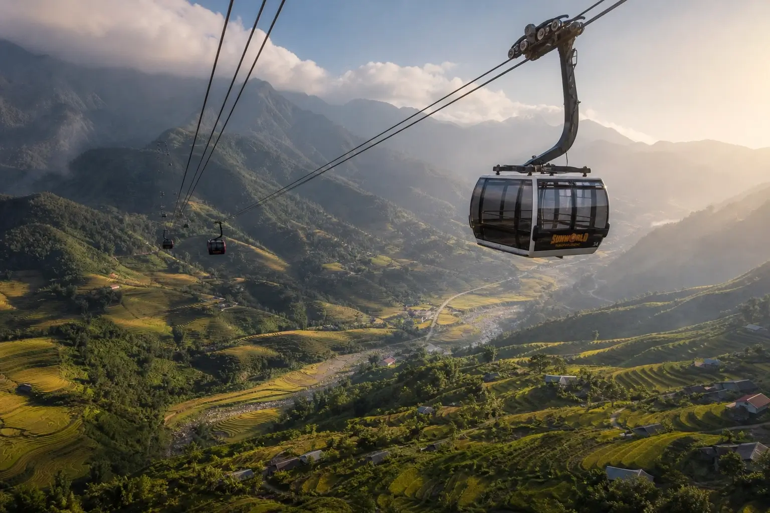
Sapa sits in the valley below. The town is the staging point. Two types of traveler arrive here and they want completely different things, which is why most guides fail them by writing a single generic section about “Sapa.”
The first type takes the Sun World Fansipan Legend cable car — a three-rope gondola system that holds the Guinness World Record for greatest elevation difference. It covers 3,143 meters of ascent in roughly 15 minutes of floating silence above terraced fields and Hmong villages below. Anyone with moderate mobility and half a day can do this. It’s not a compromise — the ride itself is spectacular.
The second type hikes. The summit trek takes 2–3 days, requires a licensed guide (mandatory for overnight summit routes), and moves through dense subtropical forest, bamboo thickets, dwarf azalea zones, and finally harsh alpine terrain at the top. What most guides skip is that the difficulty rating shifts dramatically based on season and chosen trail. The western approach in October or November is manageable for hikers with basic fitness. That same route after a July monsoon? Technically different and significantly more demanding.
I’ve seen conflicting data on guide requirements — some sources say guides are “strongly recommended,” others describe them as legally required. My read, based on current trekking operator documentation: a licensed guide is mandatory for any route involving overnight camping near the summit. Day hikes to lower elevations on established paths carry no such legal requirement, though a local guide still adds significant value for route safety and cultural context.
Sapa O’Chau is the trekking company worth booking specifically. Founded by a Hmong woman from a village outside Sapa, it’s staffed almost entirely by ethnic minority guides who explain the cultural landscape — the meaning of terracing patterns, the significance of forest sections, the relationship between altitude and crop types — not just the direction of the next switchback. For culturally responsible vietnam mountain trekking, they’re the benchmark.
Beyond Fansipan, the Hoang Lien Son range has peaks worth knowing:
- Ta Xua (2,865m) in Son La province — famous among Vietnamese youth travelers for “cloud hunting,” the phenomenon where cloud inversions completely swallow the valleys below, leaving hikers standing above a white ocean. The “Dinosaur Spine” ridge walk here is genuinely striking at dawn.
- Lao Than (2,860m) in Y Ty — delivers exceptional sunsets with a fraction of Fansipan’s crowd pressure, and rewards hikers with an alien-like landscape of wind-twisted ancient shrubs.
Quick note: both Ta Xua and Lao Than require early-morning starts for the cloud inversion effect. This isn’t scenery you can sleep in for.
The Ha Giang Highlands and Dong Van Karst Plateau
Ha Giang province in Vietnam’s far north isn’t technically a mountain range in the geological sense. It’s a high plateau of karst limestone formations, recognized by UNESCO as the Dong Van Karst Plateau Geopark. But it functions as the most dramatic mountain experience in the country for the traveler on the ground.
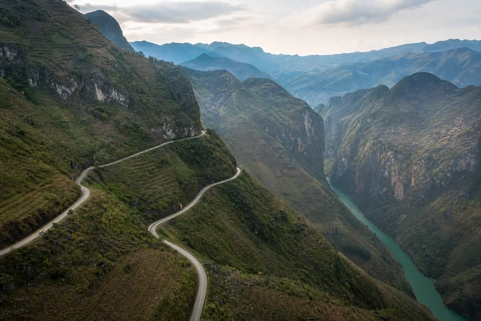
Access is through the Ha Giang Loop — a roughly 350-kilometer motorbike circuit through the plateau. The centerpiece is the Ma Pi Leng Pass, known as the “King of Passes,” at approximately 2,000 meters. The road was carved into sheer limestone cliffs by hand during the 1960s by youth volunteers working on rope harnesses over a 6-year period. That human history is embedded in every kilometer of the drive. The Nho Que River, visible 800 meters below from the main viewpoint, looks like a glowing green thread.
Look — if you want the most visually dramatic mountain road in Southeast Asia and you’re comfortable with some physical risk and logistical complexity, this is the right choice. The Ha Giang Loop is not for everyone, and the articles that describe it as simply “adventurous” do a disservice.
Some experts argue the loop is becoming over-touristed and has lost its authenticity. That’s valid for the main towns on the circuit — Dong Van and Meo Vac have grown noticeably in the past few years. But if you’re dealing with the actual riding sections — the Ma Pi Leng stretch at 6am, the Lung Cu road near the Chinese border at dusk — the landscape is unchanged. The rock doesn’t care about Instagram.
Practical Ha Giang specifics worth knowing:
- Foreign visitors require a separate permit, obtained at the Ha Giang Tourism Office upon arrival (typically a 30-minute process; bring your passport)
- Budget 4–5 days minimum for the full loop — 2 days is possible but produces a rushed experience
- Renting a manual motorbike independently is possible but inadvisable for riders without confident mountain road experience; hiring a local “easy rider” guide driver eliminates the risk and adds historical context along the route
- October–November is peak season; buckwheat flowers bloom pink across the plateau, and skies are clearest post-monsoon
- March–April is the secondary peak — less crowded, warmer, with plum and peach blossoms in early spring
Central Highlands: The Truong Son Range and Da Lat
The Truong Son range — called the Annamite Range in older Western geographic literature — runs along Vietnam’s western border with Laos and Cambodia for over 1,000 kilometers. It’s the longest mountain system in the country and consistently the least covered in travel content, which tends to treat it as background scenery rather than a destination in its own right.
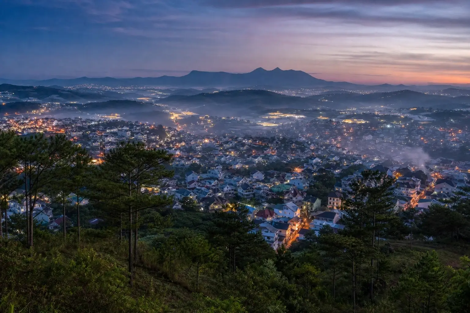
The most accessible entry point is Da Lat, a highland city at 1,500 meters elevation in Lam Dong province. It was developed as a French colonial hill station in the early 20th century and retains that layered character: pine forests, strawberry farms, waterfalls, and French-era architecture sitting alongside Vietnamese market culture and one of the country’s best coffee regions.
Here’s the thing: most hikers searching for the best mountains in vietnam overlook Da Lat entirely because the peaks don’t sound impressive on paper. The highest accessible summit in the area, Lang Biang Mountain at 2,169 meters, is a comfortable 4–6 hour return hike from the trailhead. No guide required on the main route. No cable car, no permit, no overnight camping logistics.
That accessibility is either a strength or a limitation, depending on what you’re looking for.
To visit Lang Biang Mountain, follow these steps:
- Travel from central Da Lat to the Lang Biang trailhead — approximately 12km north by taxi or motorbike.
- Pay the entrance fee at the trailhead gate (approximately 50,000 VND for independent hikers as of 2024).
- Choose the K’Ho village foot trail (4–6 hours return, rewarding cultural context) or the jeep road to the lower summit (faster, less scenic).
- Reach the first peak at around 2,100 meters for panoramic views over the Da Lat valley and surrounding highlands.
- Begin the descent by 3:00–3:30 PM — afternoon cloud rolls in quickly and obscures the views fast.
The Central Highlands make particular sense for travelers who want mountain atmosphere, cooler temperatures (Da Lat averages 17–20°C year-round), and access to Vietnam’s world-class robusta coffee culture — all without building a separate northern itinerary. Best months are November through March.
How to Pick Your Vietnamese Mountain Based on Fitness and Time
This is the question every article dances around without answering directly.
To choose the right vietnamese mountain for your trip, follow these steps:
- Assess your fitness — can you do a 2–3 day trek, or do you need cable car access?
- Fix your available time — Ha Giang Loop needs 4–5 days minimum; Fansipan cable car works in half a day.
- Check your season — northern peaks peak Sept–Nov; Central Highlands peak Nov–Mar.
- Match to your flight hub — north (Hanoi base → Sapa or Ha Giang) or south (Ho Chi Minh City / Da Lat direct).
One opinion worth pushing back on — and why it’s still correct:
The instinct to “fit in all three regions” is understandable. Vietnam is long and travelers want to maximize the trip. But spreading time across Sapa, Ha Giang, and Da Lat in a standard 2–3 week Vietnam itinerary produces a fragmented experience where you’re always traveling toward the next place instead of absorbing the one you’re in. One mountain system, done over 4–5 full days, will almost always be more memorable than three mountain regions each visited in 2-day passes.
That’s a direct counter to most Vietnam itinerary articles. It’s also the right call for most travelers.
Users who’ve tried to do all three often report the same outcome: they remember the bus rides between regions more vividly than the regions themselves.
Vietnam Mountain Q&A
What’s the best mountain in Vietnam to visit for first-timers?
A: Fansipan in Sapa is the clearest starting point — it’s Vietnam’s highest peak and reachable by cable car in 15 minutes without any trekking experience. The scenery is legitimately dramatic, and Sapa’s infrastructure makes logistics straightforward.
How do I get to the mountains in Vietnam from Hanoi?
For Sapa and Fansipan, take an overnight train to Lao Cai station (8–9 hours), then a 30-minute bus or taxi to Sapa town. For Ha Giang, direct buses from Hanoi’s My Dinh station run around 6–7 hours. Da Lat requires a flight from Hanoi (roughly 2 hours) or a long overland journey.
Should I hire a guide for vietnam mountain trekking?
For Fansipan summit overnight routes, a licensed guide is legally required. For Ha Giang Loop, hiring a local easy-rider driver is strongly advisable unless you have confident mountain motorbike experience. Lang Biang in Da Lat can be done independently on the main trail with no guide needed.
When is the best time to visit vietnam mountain ranges?
September through November is the strongest window for northern ranges — clear skies, harvest-season terraces, and manageable temperatures. For the Central Highlands and Da Lat, November through March offers the most stable weather. Avoid July–August in the north: monsoon rains make many trails slippery and visibility poor.
Why does Sapa get more tourists than Ha Giang if Ha Giang looks more dramatic?
Infrastructure is the entire answer. Sapa has the Fansipan cable car, direct overnight trains from Hanoi, established hotels, and day-trip feasibility. Ha Giang requires a separate permit, motorbike confidence or a hired driver, and a minimum of 4–5 days — a filter that removes most short-itinerary travelers from consideration.


")

No Comment! Be the first one.