


Vietnam War Locations: Key Cities, Battlefields, and What Made Each One Matter
The locations of the Vietnam War span the entire length of the country, from Hanoi in the north to the Mekong Delta in the far south. Combat unfolded across five distinct military regions — North...

The locations of the Vietnam War span the entire length of the country, from Hanoi in the north to the Mekong Delta in the far south. Combat unfolded across five distinct military regions — North Vietnam, the Demilitarized Zone (DMZ), Central Vietnam, the Central Highlands, and the southern Mekong basin — each with a different strategic role and a different kind of war being fought within it.
Most articles give you a list of sites to visit. That’s not what this is.
This guide is built around the question historians, veterans, and serious students actually ask: why did the war happen there? What made each city, valley, and stretch of jungle worth fighting over? You’ll come away with a regional framework — not just a set of names.
This guide covers the primary combat locations of the American phase of the war (1965–1975). It does not address the earlier French Indochina War in depth, nor does it cover the Cambodian and Laotian operations in detail.
The Five Military Regions: How to Think About Vietnam War Geography
Before naming cities, you need a frame.
The Vietnam War wasn’t one conflict in one place — it was several overlapping wars, each shaped by the terrain it was fought in. The country divides naturally into five military zones that help make sense of the whole. North Vietnam was the strategic heartland of the communist war effort, targeted relentlessly from the air but never invaded on the ground. The DMZ — the strip along the 17th Parallel — was where North and South were formally divided, and where some of the war’s bloodiest conventional battles happened. Central Vietnam, anchored by Hue and Da Nang, became the arena for the Tet Offensive’s urban warfare. The Central Highlands were where the ground war was most intense — remote firebases, dense jungle, and the ambush tactics that defined the conflict’s character. And the Mekong Delta in the south was where the Viet Cong maintained their strongest rural base, fighting a guerrilla war that American forces struggled to counter for a decade.
Here’s the thing: most people picture the Vietnam War as a jungle war fought somewhere vague. The reality is far more specific — and far more strategically coherent.
According to the Pritzker Military Museum & Library, the 1968 Tet Offensive alone involved simultaneous attacks on 13 cities across the central region, plus Saigon — demonstrating just how geographically distributed the conflict actually was.
North Vietnam: Hanoi, Haiphong, and the Air War
Hanoi was never invaded by U.S. ground troops. That single fact — which most introductory accounts gloss over — shapes everything about how the northern campaign was fought.
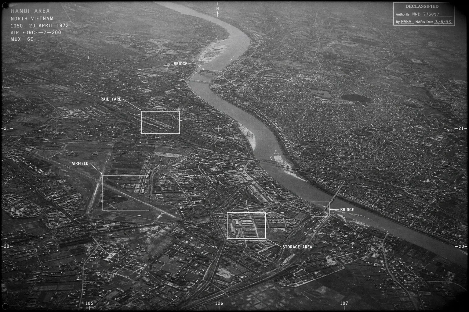
The entire U.S. strategy in North Vietnam was aerial. Operation Rolling Thunder (1965–1968) and Operation Linebacker I and II (1972) targeted Hanoi and the port city of Haiphong — Vietnam’s main northern gateway for Soviet and Chinese military aid. The December 1972 Christmas Bombings dropped more tonnage on Hanoi over 12 days than the entire Korean War had seen in total, according to records held by the Pritzker Military Museum & Library.
Haiphong mattered for one reason: ships. Mining the harbor and destroying its infrastructure was the bluntest available tool for cutting the North’s supply chain. The political cost of doing so — risking Soviet or Chinese ships — kept American planners hesitant for years.
In Hanoi itself, Hoa Lo Prison — known to American POWs as the “Hanoi Hilton” — housed downed U.S. pilots throughout the war, including Senator John McCain, who was detained there for over five years after being shot down in 1967. It’s now a museum open to visitors.
Quick note: Huu Tiep Lake in central Hanoi still holds the wreckage of a B-52 shot down during the 1972 bombing campaign. A mangrove has grown through the fuselage. It’s off most tourist itineraries and shouldn’t be.
The DMZ: The 17th Parallel and the Bloodiest Conventional Battles
The Demilitarized Zone was, by its own name, supposed to be free of combat.
It wasn’t.
Khe Sanh Combat Base sits 14 miles south of the DMZ in Quang Tri Province. In January 1968, North Vietnamese Army forces surrounded it and laid siege for 77 days. President Johnson had a scale model of the base installed in the White House Situation Room. The siege was broken in July 1968 — and then the base was demolished months later, generating a political storm over whether the lives and firepower spent defending it were justified by terrain the U.S. immediately abandoned.
I’ve seen conflicting data on this — some military historians frame Khe Sanh as a U.S. strategic success (the siege was broken, PAVN losses were staggering), while others argue the entire engagement was a North Vietnamese feint designed to pull American attention from the urban targets being prepared for Tet. My read is that both interpretations hold water, and the answer likely shifts depending on which week of the battle you’re examining.
The Vinh Moc Tunnels offer a civilian perspective that gets underweighted in military histories. Entire villages relocated underground to survive the bombing of the DMZ. Around 2,000 people lived below ground for extended periods — and 17 babies were born inside the tunnels during the war, according to Exotic Voyages (2025). The tunnels are now among the most visited DMZ sites.
The Hien Luong Bridge over the Ben Hai River marked the exact dividing line between North and South Vietnam. Its symbolic weight was enormous. Both sides repainted it in their own national colors as a form of ongoing territorial assertion.
Central Vietnam: Hue, Da Nang, and the Cities the Tet Offensive Tried to Seize
Da Nang is where the American ground war began. Period.
On March 8, 1965, 3,500 U.S. Marines waded ashore at Nam Ô Beach — the first American combat troops deployed to Vietnam. Da Nang became the country’s largest U.S. air base, a critical logistics hub, and a major launch point for operations throughout the central region. The Da Nang Air Base is now Da Nang International Airport, one of Vietnam’s busiest commercial facilities.
To locate Central Vietnam’s major war sites today, follow these steps:
- Place Da Nang on the central coast as your reference point
- Travel 70 miles north along the coast to reach Hue
- Locate the A Shau Valley roughly 40 miles west of Hue — site of Hamburger Hill (1969)
- Match each site to its strategic role using Google Maps with official site names
- Cross-reference with the Vietnam National Administration of Tourism (VNAT) heritage directory for current access hours
Hue is the location most visitors — and most general accounts — underestimate.
The city served as Vietnam’s imperial capital under the Nguyen Dynasty for over a century. That history made it a cultural symbol unlike any other city in the country. When North Vietnamese forces targeted it during the 1968 Tet Offensive, the political message was as deliberate as the military objective. Communist forces held Hue for 26 days. By the time they were driven out, roughly 50% of the city’s buildings had been destroyed, the ancient citadel had been badly damaged, and approximately 5,000 civilians were listed as dead or missing in the aftermath — many of them systematically executed during the occupation, according to the Pritzker Military Museum & Library.
Or maybe I should say it this way: Hue wasn’t just a military target. Holding the former imperial capital — even briefly — was symbolically explosive in a way that taking a jungle firebase never could be.
The citadel walls still show bullet holes. The Hue War Museum holds a collection of captured weaponry from the battle, including the tank that crashed through the gates of the Independence Palace in Saigon in 1975.
The Central Highlands: Ia Drang, Hamburger Hill, and the Ground War
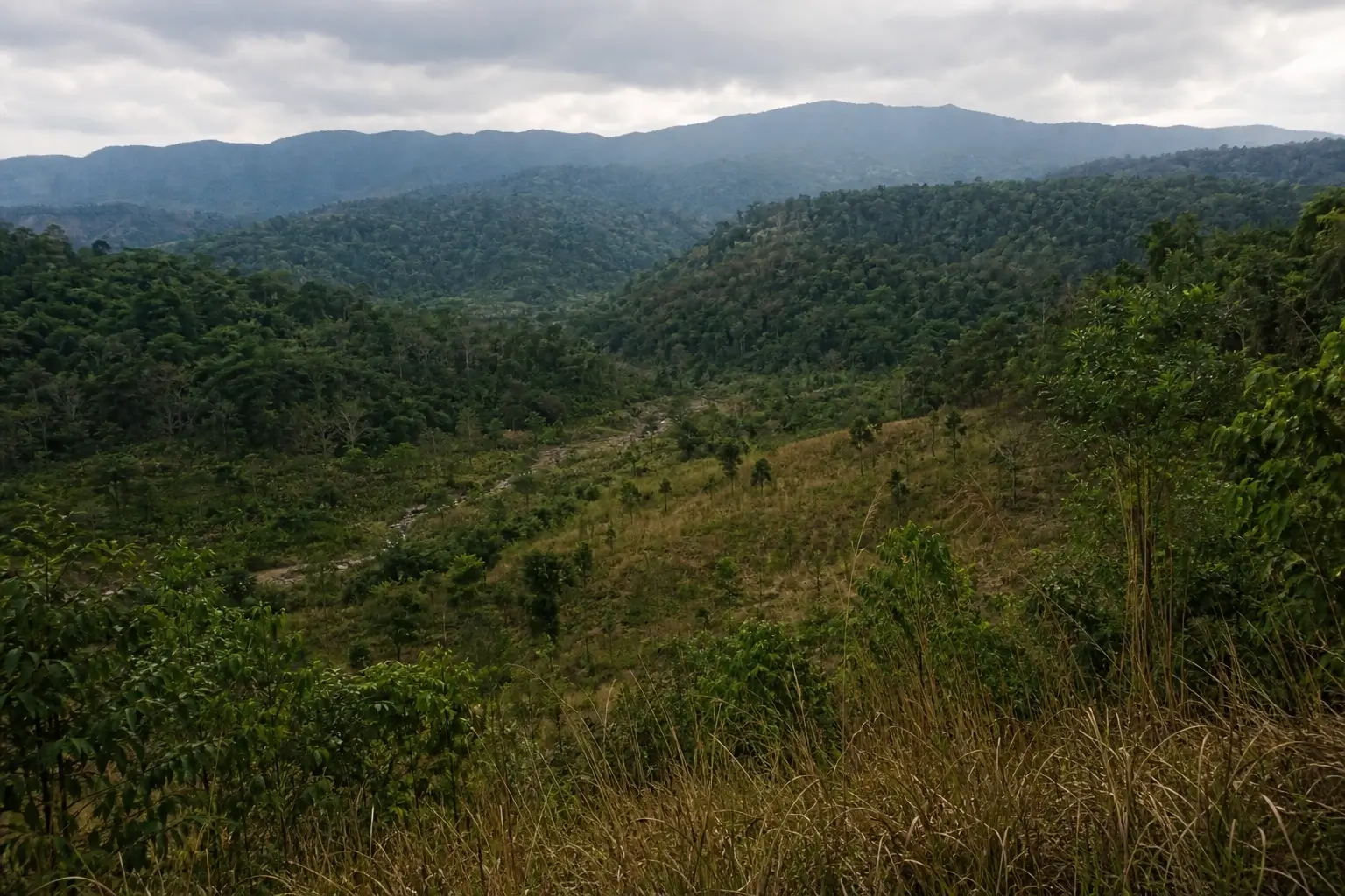
The Central Highlands were strategically critical for one reason. The Ho Chi Minh Trail fed directly into them from Laos.
Whoever controlled the Highlands controlled the movement of North Vietnamese troops and supplies into the south. That’s why U.S. commanders fought so hard for terrain that looked, on a map, like it wasn’t worth the effort.
Ia Drang Valley (November 1965) hosted the first large-scale engagement between U.S. Army and People’s Army of Vietnam (PAVN) forces. The battle established the template for the entire American strategy: helicopter-borne air mobility, mass firepower to offset enemy terrain advantages, and a focus on inflicting casualties as a measure of progress. The U.S. counted it as a victory. PAVN commanders took away their own lesson — engage Americans at close range to neutralize air support and artillery. Both sides left Ia Drang believing they’d solved the other’s strategy. Both were right. That’s what made the following decade so costly.
Hamburger Hill (May 1969, officially Hill 937 in the A Shau Valley) was taken after ten brutal days of uphill fighting — then abandoned shortly after. The political backlash in the U.S. was severe. It crystallized the public argument that a strategy of attrition was producing sacrifice without progress.
Ben Het Special Forces Base, located near the Laotian border, was one of the most remote American installations in Vietnam and saw some of the most isolated combat of the war. It’s rarely mentioned in mainstream accounts. It’s worth a dedicated visit for anyone serious about the Highlands campaign.
The A Shau Valley remains one of the most historically significant and least-visited areas connected to the war. Unexploded ordnance remains a documented hazard throughout the Central Highlands — visitors must stay on marked paths.
South Vietnam: Saigon, Cu Chi, and the Political Core
Saigon — now Ho Chi Minh City — was the capital of South Vietnam, the center of U.S. political and military operations, and the symbolic endpoint of the entire conflict.
The Reunification Palace (formerly Independence Palace) was stormed on April 30, 1975, when North Vietnamese Tank 843 crashed through its front gates at 10:45 AM. The moment was photographed and broadcast globally. It marked the end of the war. The palace has been preserved exactly as it was that day — underground war rooms, period communications equipment, vintage furniture, and final troop position maps still visible in the bunker.
The War Remnants Museum draws over 500,000 visitors annually, about two-thirds of them international, according to AP reporting (2025). Its exhibits center on Agent Orange, the My Lai massacre, and civilian casualties. Some exhibits carry a propagandistic framing — that’s a legitimate critique for specific display choices. But the core photographic record it holds is real, and the scale of what those photographs document is not in dispute.
Cu Chi Tunnels, roughly 25 miles northwest of the city, served as the Viet Cong’s command infrastructure for the Tet Offensive. The network extended over 250 kilometers at its peak and included living quarters, weapons factories, field hospitals, and command centers. According to the Ho Chi Minh City Department of Tourism (2025), the Cu Chi Tunnels now attract over 1.5 million visitors annually — making them one of the most-visited heritage sites in Southeast Asia.
Look — if you’re planning a war history itinerary in Vietnam, the Cu Chi Tunnels and Reunification Palace are non-negotiable starting points. But don’t let those two consume the entire visit. Huu Tiep Lake, the A Shau Valley, and Ben Het Special Forces Base are where the war becomes less cinematic and more real.
The Mekong Delta: Guerrilla War in the South
South of Saigon, the Mekong Delta was the Viet Cong’s strongest rural stronghold — and one of the hardest environments American forces ever tried to operate in.
Vinh Long served as a major U.S. Army airfield along the Mekong River. The “Brown Water Navy” — river patrol craft operating across the Delta’s 4,000-kilometer canal network — became a defining feature of the southern war, a form of combat with almost no precedent in U.S. military history.
Ap Bac (January 1963) is the battle that most history accounts underweight, and that underweighting is a mistake.
It happened early — before significant U.S. troop deployment — and it demonstrated clearly that South Vietnamese ARVN forces were being outfought by the Viet Cong even with American advisors and helicopter support present. David Halberstam covered it for the New York Times. The Pentagon disputed his reporting. Halberstam was right. The battle’s outcome, and the military command’s public denial of what it meant, set a pattern of credibility failures that would haunt the entire American effort.
Some experts argue the Ap Bac engagement was too early and too small to carry strategic weight. That’s valid as a purely tactical assessment. But if you’re trying to understand why the war went the way it did, Ap Bac — a single, small, largely forgotten battle in a rice paddy — tells you more than almost anything else.
Quick Comparison: Vietnam War Locations by Region
| Location | Region | Primary Role in the War | Visitable Today? |
|---|---|---|---|
| Hanoi / Hoa Lo Prison | North Vietnam | Air war target; U.S. POW detention | Yes — open museum |
| Haiphong Port | North Vietnam | Soviet/Chinese supply entry point | Yes — city and port accessible |
| Khe Sanh Combat Base | DMZ / Quang Tri | 77-day siege, 1968 | Yes — on-site museum + artifacts |
| Vinh Moc Tunnels | DMZ | Underground civilian village | Yes — guided tours available |
| Hue / Imperial Citadel | Central Vietnam | Tet Offensive urban battle, 1968 | Yes — citadel + war museum |
| Da Nang / Nam Ô Beach | Central Coast | First U.S. Marine landing, March 1965 | Yes — public beach |
| Ia Drang Valley | Central Highlands | First major U.S.-PAVN battle, 1965 | Limited — terrain access varies |
| Cu Chi Tunnels | South Vietnam / HCMC | Viet Cong command and supply hub | Yes — 1.5M visitors/year |
| Reunification Palace | Saigon / HCMC | Fall of South Vietnam, April 30, 1975 | Yes — preserved as war site |
| Ap Bac Battlefield | Mekong Delta | Early Viet Cong victory, 1963 | Yes — outdoor exhibition |
Frequently Asked Questions
What cities were most affected by the Vietnam War?
Hue, Saigon, Da Nang, Quang Tri, and Khe Sanh saw the heaviest fighting. Hue was nearly 50% destroyed during the 26-day Tet Offensive battle in 1968, with roughly 5,000 civilians killed or missing.
Where did most of the Vietnam War take place?
Most ground combat occurred across South Vietnam — concentrated in the Central Highlands, the DMZ corridor, and the Mekong Delta. North Vietnam was targeted by major U.S. air campaigns but never invaded by ground forces.
What was the most strategically important location in the Vietnam War?
The DMZ along the 17th Parallel functioned as the war’s defining geographic boundary. But Saigon, as the South’s political capital and logistics center, was arguably the single most critical location — both sides knew that whoever held it held the war.
How do I find Vietnam War battle sites on a map?
Search Google Maps using official site names such as “Khe Sanh Combat Base” or “Cu Chi Tunnels.” The Vietnam National Administration of Tourism (VNAT) at vietnamtourism.gov.vn maintains an official heritage site directory with current access details.
Are Vietnam War locations still visitable today?
Yes, The Cu Chi Tunnels, Khe Sanh Combat Base, the DMZ, Hoa Lo Prison, and the War Remnants Museum are all open, well-preserved, and accessible via guided tours or independently. Some Central Highlands locations have limited access due to unexploded ordnance.


")

No Comment! Be the first one.