


Mt. Lemmon Today: Weather, Road, Snow, and Webcam Conditions
Mt. Lemmon today refers to current weather, road, and snow conditions on Mount Lemmon in the Santa Catalina Mountains above Tucson, Arizona. Because the mountain spans a 6,000-foot elevation range,...

Mt. Lemmon today refers to current weather, road, and snow conditions on Mount Lemmon in the Santa Catalina Mountains above Tucson, Arizona. Because the mountain spans a 6,000-foot elevation range, from Sonoran Desert floor to 9,157-foot alpine summit, conditions at the base and summit can differ by 30°F or more, with the road status changing hour by hour after storms.
Forget the 7-day forecast. If you’re deciding whether to drive up this morning, you need three things: is Catalina Highway open, how deep is the snow, and what are the live cameras showing right now. This page puts all of it in one place.
Your fastest starting points:
- Road status hotline: Pima County Sheriff’s Department — (520) 351-3351
- Live webcam network: mtlemmon.com/web-cams (11 cameras, near-real-time)
- Official zone forecast: NWS Tucson — Zone AZZ514, covering the Santa Catalina and Rincon Mountains including Summerhaven
That’s the short version. What follows explains how to use each source correctly — because the wrong camera at the wrong elevation, or a hotline recording from 10 hours ago, sends you up unprepared.
Is Catalina Highway Open Today?
Mt. Lemmon today conditions — specifically road status — are controlled by Pima County, not Arizona DOT and not the Coronado National Forest. That distinction matters more than most visitors realize.
According to the Pima County Sheriff’s Department, the official road condition hotline is (520) 351-3351. The recording is updated only when conditions change — so if the last update was at 6 PM the previous evening, that recording is still the current official status until someone changes it. Call in the morning, before you leave, not the night before.
To check if Catalina Highway is open today, follow these steps:
- Call (520) 351-3351 and listen for the current open/closed status and any chain requirements.
- Check a live webcam at the elevation zone you’re targeting — road cam for pavement conditions, Ski Valley cam for upper-mountain snowpack.
- Pull up the NWS AZZ514 zone forecast for active storm warnings or wind advisories over the Catalinas.
- If there’s any ice risk in the forecast, confirm 4WD or chain requirements before leaving home.
Each step takes under two minutes. Skipping step one and relying on a webcam alone is the most common mistake — a camera showing snow on the slopes does not mean the road is legally open to the public.
What most visitors don’t realize: ice closes the road more often than snow depth does. A storm that drops six inches on a Thursday night can leave a driveable road by Friday afternoon — but if it drops to 28°F overnight on Friday, that slush refreezes into sheet ice and the road closes again by Saturday morning. A thin glaze is harder to drive than eight inches of fresh powder.
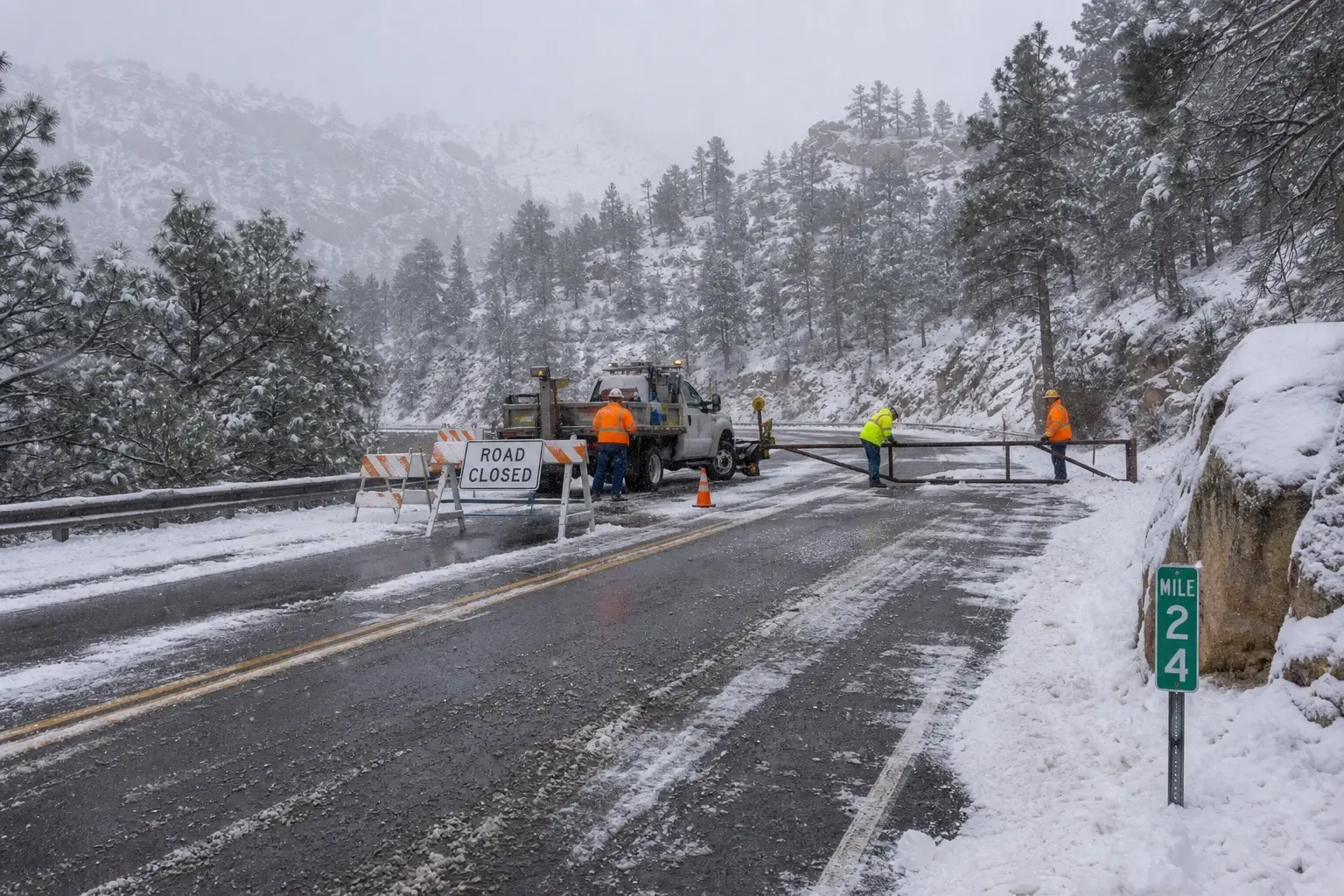
Look, if you’re loading up the car on a winter Saturday and you haven’t checked within two hours of leaving, you’re gambling. The gate at Milepost 24 will be staffed, and they will turn you around if your vehicle doesn’t meet requirements.
Some people argue you can judge road safety by watching the webcam for 10 minutes and reading tire tracks. That’s a reasonable call for experienced drivers who know exactly what icy road surface looks like in a low-resolution cam feed. For everyone else — especially with passengers or a 2WD sedan — just call.
How Much Snow Is on Mt. Lemmon Right Now?
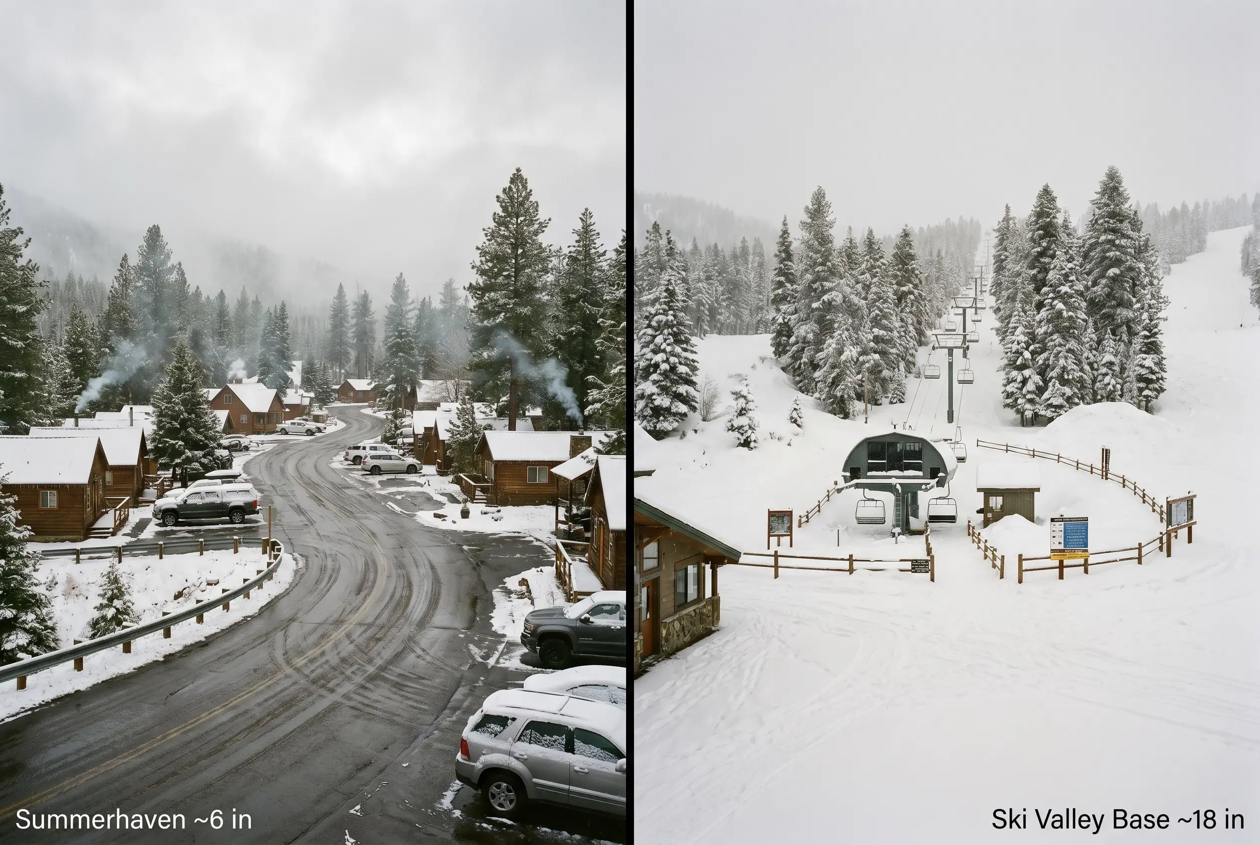
Mt. Lemmon Ski Valley receives an average of 160 inches — roughly 406 cm — of snow annually, according to tracking data from Mt. Lemmon Hotel (2026). Summerhaven sits about 1,000 feet lower than Ski Valley and sees meaningfully less accumulation. The base of Catalina Highway? Essentially none.
The mountain compresses the equivalent of a Canada-to-Mexico climate transition into a 27-mile drive. That means snow depth isn’t a single number — it’s a question of where on the mountain you’re asking about.
Quick Comparison — Snow Depth by Elevation Zone
| Zone | Elevation | Typical Mid-Season Depth | Best Use Case | Limitation |
|---|---|---|---|---|
| Lower Catalina Highway | ~3,000 ft | None to trace | Road cycling, desert hiking | No snow activities |
| Summerhaven Village | ~7,600 ft | 4–12 inches | Family snow play, snowshoeing | Variable, melts fast in sun |
| Mt. Lemmon Ski Valley | ~8,200 ft | 12–24+ inches | Skiing, sledding, tubing | Road may require chains |
| SkyCenter Summit Area | ~9,100 ft | 18–30+ inches | Photography, backcountry | Cold, wind-exposed, gated area |
For a running accumulation total specific to Summerhaven, Mt. Lemmon Hotel maintains a season snowfall tracker updated after each storm — it’s the most granular community-level source available short of calling a local business directly. For forecast accumulation ahead of an incoming system, the NWS AZZ514 zone forecast is the authoritative number.
I’ve seen conflicting figures between different weather aggregators on single-storm totals — some sources cite Summerhaven totals, others cite Ski Valley, and they’re rarely labeled clearly. My read: always identify which elevation a reported snow total came from before using it to plan. A “6-inch snowfall on Mt. Lemmon” reported by Tucson news usually means Summerhaven. Ski Valley likely got more.
What most guides skip entirely is the melt-refreeze timing. Sun exposure on south-facing slopes strips 4–6 inches of snow by early afternoon on a clear day. If you’re going specifically for snow play with kids, a Saturday morning arrival the day after a Thursday-night storm gives you the deepest, freshest conditions. By Sunday afternoon on a sunny weekend, you might find more mud than snow below 8,000 feet.
Which Webcam Shows What — A Camera-by-Camera Breakdown
The Mt. Lemmon webcam network covers 11 locations across different elevation zones. Most visitors click the first camera in the list, see it looks fine, and drive up — only to find conditions are different at the elevation they were actually headed to.
Here’s how to match camera to purpose.
Cameras for Road and Pavement Conditions
The General Hitchcock Highway cam and the Catalina Highway cam sit at mid-mountain elevations where icing is most common. These are your first check if you’re looking at road surface — not scenery. A dark, wet road with no snow doesn’t mean the upper sections are clear.
Cameras for Snow Depth and Upper-Mountain Conditions
The Mt. Lemmon Ski Valley webcam and the Aspen Draw cam sit at higher elevations and give you a read on actual snow coverage. Bare ground with patches, versus full coverage, versus powder on top of base — you can read those conditions visually in about 30 seconds. The Ski Valley cam specifically is updated frequently during ski season and is the fastest way to see whether the slopes are open and skiable.
The SkyCenter All-Sky Camera
The University of Arizona’s Steward Observatory operates an all-sky camera at the 9,100-foot SkyCenter summit, accessible at neofixer.arizona.edu/css/lemmon/. Quick note: this camera points upward at the sky dome, not outward at the mountain or road. It’s designed for cloud-cover monitoring ahead of public stargazing programs. It tells you whether the sky is clear for astronomy — not whether there’s ice on Ski Run Road.
For landscape and condition views at the summit, use the General Store or Radio Ridge cams from the mtlemmon.com network instead.
Your Go/No-Go Checklist Before Driving Up
Run through this before you leave the driveway.
- ✅ Called (520) 351-3351 and road is confirmed open
- ✅ At least one live webcam shows clear or manageable conditions at your target elevation
- ✅ NWS AZZ514 shows no active storm warning or wind advisory for the Santa Catalinas
- ✅ You have 4WD or AWD — or chains — if any cam shows snow or slush on road surface
- ✅ You’ve accounted for the temperature differential (Tucson at 75°F does not mean Summerhaven isn’t sitting at 31°F)
Stop. Two or more boxes unchecked? Wait, or reschedule.
This works best for day-trippers making a same-morning decision. It won’t help if you’re planning an overnight stay during an active storm system — in that case, call Mount Lemmon Lodge or the Mt. Lemmon Hotel directly for on-the-ground conditions the hotline recording may not reflect yet.
Pine Mountain Observatory Webcam vs. Mt. Lemmon SkyCenter — They’re Not the Same Place
This trips up a surprising number of people.
“Pine Mountain Observatory webcam” is a real, active camera — operated by the University of Oregon Department of Physics at a 6,300-foot site in central Oregon. It is completely unrelated to Arizona. If you searched that term and wound up here, you were looking for the wrong place entirely.
What you’re actually looking for in Arizona is the University of Arizona Mt. Lemmon SkyCenter, operated by Steward Observatory at the 9,157-foot summit of Mt. Lemmon. Their all-sky camera is at neofixer.arizona.edu. Their public programs — the flagship SkyNights stargazing experience — run year-round and include a five-hour guided session, light dinner, and access to the Schulman 32-inch telescope, which is the largest dedicated public telescope in the Southwest.
Two observatories. Two different universities. Two different states.
If you’re looking for live sky conditions for astronomy purposes on Mt. Lemmon, the SkyCenter’s neofixer page is the correct destination. If you’re looking for road or snow conditions, it’s the wrong tool entirely — see the webcam section above.
FAQs
What’s the best way to check if Catalina Highway is open right now?
Call the Pima County Sheriff’s road condition hotline at (520) 351-3351. It’s updated after each road status change and is more reliable than any weather app or recent social media post for gate and chain requirements.
How much snow is on Mt. Lemmon today?
It depends on elevation. According to Mt. Lemmon Hotel’s seasonal tracker (2026), Summerhaven typically sees 4–12 inches mid-season while Mt. Lemmon Ski Valley at 8,200 feet can accumulate 24 inches or more. Check mtlemmon.com live webcams for a current visual.
Should I use 4WD to drive up Mt. Lemmon in winter?
Yes, if any live webcam shows snow, slush, or wet road surfaces above Milepost 18. Pima County can require chains or 4WD/AWD past Milepost 24 during and after storms — AWD alone may not be sufficient on refrozen overnight ice.
Why does the Mt. Lemmon SkyCenter webcam not show the mountain or road?
The SkyCenter’s all-sky camera at neofixer.arizona.edu points upward to monitor cloud cover for astronomical observations. It’s not a landscape or road conditions camera. For road and snow conditions, use the 11-camera network at mtlemmon.com instead.
When should I check Mt. Lemmon conditions before a day trip?
Check the NWS AZZ514 forecast the night before for any incoming storm, then call (520) 351-3351 and check a webcam between 7–8 AM the morning of your trip. Conditions can change overnight as daytime melt refreezes — morning is always more accurate than the night before.


")

No Comment! Be the first one.